

LiDAR in Mapping Market to Surpass USD 27.3 billion by 2035
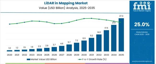
The global LiDAR in Mapping Market is entering a decade of accelerated expansion, driven by unprecedented demand for high-resolution geospatial data, smart infrastructure development, and rapid adoption across autonomous systems. Valued at USD 2.9 billion in 2025, the market is projected to surge to USD 27.3 billion by 2035, registering an impressive 25.0% CAGR. This growth reflects rising reliance on LiDAR for topographic mapping, environmental assessment, navigation, and digital transformation initiatives across both public and private sectors.
Subscribe for Year-Round Insights → Stay ahead with quarterly and annual data updates:
https://www.futuremarketinsights.com/reports/sample/rep-gb-25765
From 2021 to 2025, the market moved steadily from USD 1.0 billion to USD 2.9 billion, marking early-stage adoption across surveying, forestry, and urban planning. A major inflection point emerges in 2025, initiating rapid growth toward USD 7.2 billion by 2030, supported by technological advancements, cost reductions, and widening use across autonomous mobility, smart cities, and precision agriculture. A second acceleration phase begins in 2031, pushing the market to USD 27.3 billion by 2035, reflecting mainstream adoption and broader integration with AI-enabled decision systems, digital twins, and real-time infrastructure intelligence.
What Is Driving the LiDAR in Mapping Market?
LiDAR’s ability to deliver sub-centimeter accurate 3D models gives it a strategic advantage over conventional surveying methods. Governments and enterprises are increasingly deploying LiDAR to cut project timelines, enhance mapping precision, and support data-intensive planning workflows. Integration with AI, GNSS, drone platforms, and automated analytics is boosting LiDAR’s role in real-time environmental monitoring, transportation planning, and resilience infrastructure.
Major growth drivers include:
- Rising global investment in smart cities, digital twins, and infrastructure modernization
- Increased demand for accurate terrain data for flood modeling and climate resilience
- Growth of autonomous vehicles, requiring high-precision, real-time 3D mapping
- Widespread adoption in construction, surveying, mining, and energy sectors
Segmental Insights
Airborne LiDAR will lead with 39.5% market share in 2025, as its ability to capture large-area topography rapidly and accurately makes it indispensable for national surveys, forest management, and coastal mapping. Enhanced miniaturization and UAV-based airborne systems are further accelerating adoption.
Hardware components will represent 54.2% of the market in 2025, driven by demand for advanced laser scanners, IMUs, and GPS units capable of supporting complex mapping missions. As LiDAR hardware becomes more compact, efficient, and affordable, accessibility increases for mid-scale users.
Construction and surveying applications—projected to hold 26.8% share in 2025—continue to dominate due to the industry’s rising need for accurate terrain models, volume calculations, and digital documentation to support modernized infrastructure planning.
Regional & Country Growth Outlook
The LiDAR in mapping market is expanding globally, with notable momentum in:
- China (33.8% CAGR): Driven by large-scale smart city projects, high-speed rail expansion, and advanced manufacturing.
- India (31.3% CAGR): Adoption rising in transportation planning, agriculture, and national infrastructure programs.
- Germany (28.8% CAGR): Strong demand from automotive innovation, renewable energy development, and digital engineering.
- UK (23.8% CAGR): Use increasing in environmental monitoring, renewable energy site planning, and autonomous mobility.
- USA (21.3% CAGR): High uptake in defense, precision agriculture, construction, and autonomous vehicles.
Across more than 40 countries, LiDAR adoption is accelerating as nations prioritize sustainability, mobility modernization, and data-driven planning.
Market Challenges & Opportunities
Key constraints include high hardware costs, regulatory complexities for drone-based scans, and the need for skilled operators. However, opportunities in drone-integrated LiDAR, autonomous navigation, and real-time geospatial analytics are rapidly expanding.
Miniaturized LiDAR, enhanced signal processing, and AI-assisted mapping workflows are emerging as transformative trends, fueling use cases from precision farming to transportation networks and smart infrastructure monitoring.